
- Webcode: 482108 • Mfr: 299663
Product Highlights
- 59 mins Max. Flight Time
- 40 km (25 mi) Video Transmission
- 7000 m (22966') Max. Takeoff Altitude
- 20254 mAh Capacity
- 977 Wh
- IP 55 IP Rating
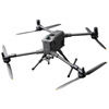
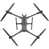
DJI Matrice 400 SP Plus
DJI Matrice 400 SP Plus- Toronto Special Order
- Ottawa Special Order
- Mississauga Special Order
- Calgary Special Order
- Edmonton Special Order
For Québec residents: See our Bill 29 Disclosure at the bottom of this page or click here for more info.
Overview
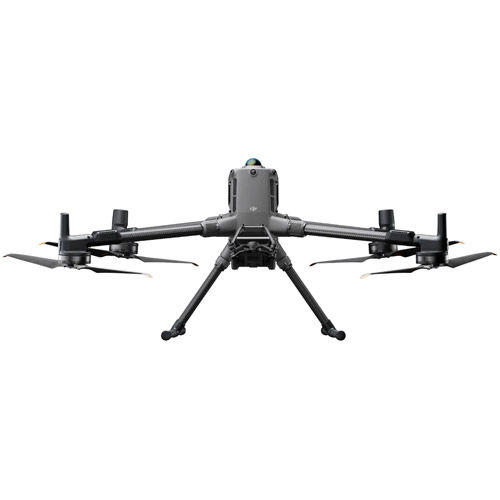
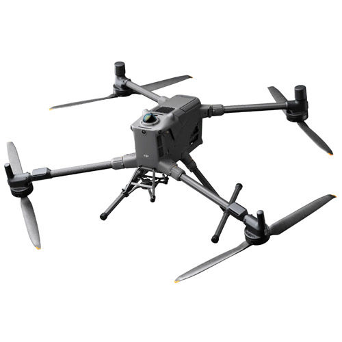
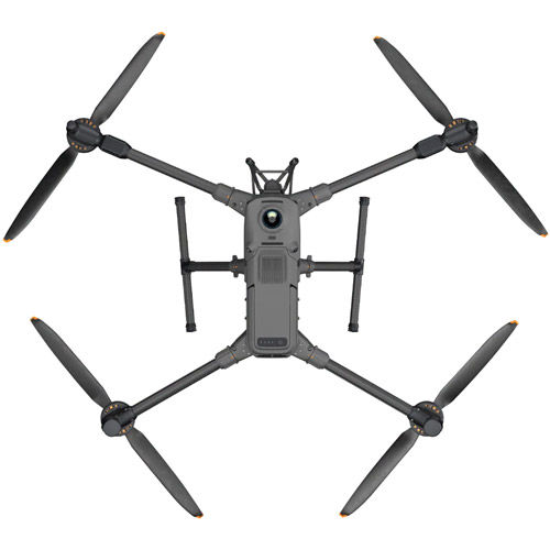
Matrice 400 SP Plus
DJI Matrice 400, the enterprise flagship drone platform, boasts an impressive 59-minute flight time, a payload capacity of up to 6 kg, and integrated rotating LiDAR and mmWave radar for power-line-level obstacle sensing. It also supports the O4 Enterprise Enhanced Video Transmission and Airborne Relay Video Transmission, ensuring safer handling and easier operations. Combining Smart Detection with visible and thermal imaging, AR projection, ship-based takeoff/landing, and advanced automation, Matrice 400 excels in emergency response, power inspections, mapping, and AEC.
Extended Flight Time, High Speed Performance
Matrice 400's flight capabilities are outstanding, offering up to 59 minutes of forward flight time even with a payload, and up to 53 minutes of hovering duration. These capabilities make it a reliable tool for long-duration and continuous operations such as search and rescue, firefighting, and large-scale mapping. It can also avoid large obstacles like buildings and mountains at flight speeds of up to 25 m/s.
Multi-Payload, Multi-Scene
Matrice 400’s strong payload capacity allows it to easily meet the demands of a wide range of applications. With a maximum payload capacity of 6 kg, Matrice 400 supports seamless switching between a single downward gimbal and a dual downward gimbal. It also features a third gimbal connector on the underside for additional flexibility. The aircraft is equipped with 4 external E-Port V2 ports, enabling simultaneous mounting of up to 7 payloads. Depending on the task, Matrice 400 can be equipped with the Zenmuse H30 Series, L2, P1, S1 Spotlight, V1 Speaker, Manifold 3, or third-party payloads, thereby expanding its capabilities and unlocking the full potential of the DJI ecosystem.
Safe and Reliable Fight
Built for Challenging Conditions
Matrice 400 has a protection rating of IP55, allowing it to operate reliably in challenging conditions including heavy dust or rain. It also maintains stable performance across temperatures from -20° to 50° C (-4° to 122° F), delivering consistent results in both hot and cold conditions.
Power-Line-Level Obstacle Sensing
The Matrice 400's advanced obstacle sensing system integrates rotating LiDAR, high-precision mmWave radar, and full-color low-light fisheye vision sensors, pushing detection capabilities to unprecedented levels. The system detects even small obstacles like high-voltage power lines across mountainous terrain — even in darkness. It can penetrate rain and fog to sense its surroundings, providing enhanced safety in challenging weather conditions.
Robust Video Transmission
O4 Enterprise Enhanced Video Transmission System
Thanks to the ten-antenna system on the aircraft and the high-gain phased array antenna system on the remote controller, the O4 Enterprise Enhanced Video Transmission System can achieve image transmission up to 40 km. Matrice 400 also supports the sub2G frequency band, and when equipped with two DJI Cellular Dongle 2, it can automatically switch to the better available carrier network, providing a more stable signal even in urban interference environments or remote regions.
Airborne Relay Video Transmission
Matrice 400 has a built-in video transmission relay module. With this setup, one Matrice 400 can serve as a relay drone, flying high to provide relay signals for another Matrice 400 operating at a greater distance. This capability significantly extends the transmission range, making it ideal for search and rescue tasks as well as inspections in mountainous areas.
Aircraft Fusion Positioning
The omnidirectional sensing performance brought by rotating LiDAR, high-precision mmWave radar, and full-color low-light fisheye vision sensors provides Matrice 400 with strong positioning capabilities. It can fly stably close to glass-facade buildings or wind turbine blades and safely return from building edges, mountain bases, or bridge sides even when the return point has not been updated.
Full-Color Vision Assist
The four full-color low-light fisheye vision sensors on the aircraft provide Full-Color Vision Assist to ensure safer flight.
Enhanced Intelligency and Efficiency
Smart Detection
With Zenmuse H30 Series' visible and thermal imaging, Matrice 400 can detect vehicles, vessels, and subjects during search and rescue operations or routine flights. It also supports switching to other models, enabling the expansion of application scenarios. Additionally, it supports high-res grid photos and features powerful tracking capabilities.
Real-Time Terrain Follow
Matrice 400 supports Real-Time Terrain Follow flight in any horizontal direction. This feature can be enabled during both manual flight and automated flight routes, ensuring stable relative height to the ground. During large-scale search and rescue operations, the size of ground subjects can be kept consistent on the remote controller screen, reducing the need for frequent zoom adjustments and improving efficiency. During mapping missions, a consistent ground sampling distance (GSD) can be maintained to obtain high-precision mapping data.
Takeoff and Landing on Ships
To address the needs of offshore operations such as maritime patrol and wind turbine inspection, Matrice 400 is equipped with the capability to take off from and land on ships, supporting takeoff from stationary vessels and landing on moving vessels. By detecting landing point patterns on the deck, it can achieve safe and precise landings.
Intelligent Flight Modes
- Cruise: Activate cruise control mode to pilot the drone in a specific direction without constantly pressing the control sticks, making long-distance flights or linear inspections easier.
- FlyTo: In emergencies or disasters, the drone can automatically adjust its flight path and speed based on the surrounding environment, allowing it to reach a designated location without manual adjustments.
- Smart Track: Smart Track allows for precise subject positioning and automatic zoom adjustments, allowing you to switch between subjects easily. It can automatically reacquire a subject even if obscured briefly.
- POI: POI enables continuous observation and 3D modeling of buildings while orbiting a designated area, greatly enhancing the efficiency of fixed-point observation and modeling tasks.
Easier Automated Operations
Power Line Follow With Zenmuse L2
When equipped with the L2 LiDAR system, Matrice 400 can perform automated power transmission and distribution line following flights. It uses the rotating LiDAR to detect obstacles in real time and automatically bypasses crossing lines.
Slope Route & Geometric Route
Matrice 400 supports the planning and execution of slope and geometric routes via DJI Pilot 2 or DJI FlightHub 2. Whether conducting detailed aerial surveys of building facades, slopes, or other inclined surfaces, or collecting mapping data of individual buildings or structures, Matrice 400 can quickly plan slope or geometric routes to efficiently acquire high-precision data.
DJI Care Enterprise Plus
Comprehensive Protection | Professional Quality Assurance | Exclusive Service | Service Starts with Activation
For Québec Residents – Disclosure Under the Consumer Protection Act
In compliance with Bill 29, Vistek does not guarantee the availability of replacement parts, repair services, or maintenance or repair information for products sold by Vistek.
Coverage provided through applicable manufacturer warranties, if any, remains in effect. Customers are encouraged to contact the manufacturer directly for information regarding the availability of replacement parts, repair services, or maintenance information.
Reviews
Product Specifications
Matrice 400 SP Plus |
|
|---|---|
Aircraft |
|
|
Takeoff Weight (with propellers) |
|
|
Max Takeoff Weight |
|
| Dimensions |
|
| Max. Payload |
|
| Propeller Size |
|
| Diagonal Wheelbase |
|
| Max. Ascent Speed |
|
| Max. Descent Speed |
|
| Max. Horizontal Speed |
|
| Max. Takeoff Altitude |
|
|
Max Flight Time (no wind) |
|
| Max. Hover Time (no wind) |
|
|
Max Flight Distance (no wind) |
|
|
Max Wind Speed Resistance |
|
|
Max Yaw Angular Velocity |
|
|
Max Pitch Angle |
|
| Operating Temperature |
|
| GNSS | GPS + Galileo + BeiDou + GLONASS |
| Hovering Accuracy Range |
|
| RTK GNSS Accuracy |
|
| RTK Heading |
|
| Airborne ADS-B In |
|
| Ports |
|
| Propeller Model |
|
| Beacon |
|
| Ingress Protection Rating | IP55 |
Gimbal |
|
|
Maximum Payload for Single Gimbal Connector |
1400 g |
|
Maximum Payload for Dual Gimbal Connector |
950 g |
|
Maximum Payload for Third Gimbal Connector |
|
Sensing |
|
| Sensing Type |
|
| Forward |
|
| Backward |
|
| Lateral |
|
| Downward |
|
| Operating Environment | Forward, Backward, Left, Right, and Upward: Delicate texture on the surface, adequate light. Downward: The ground has rich textures and sufficient lighting conditions*, with a diffuse reflection surface and a reflectivity greater than 20% (such as walls, trees, people, etc.). |
| Rotating LiDAR |
|
|
Upper LiDAR (3D ToF) |
|
|
Downward 3D Infrared Range Sensor |
|
|
mmWave Radar |
Measurement Range for Power Line: 36 m for a 12.5mm steel-core aluminum stranded wire 50 m for a 21.6mm steel-core aluminum stranded wire FOV: ± 45° (horizontal and vertical) |
FPV Camera |
|
| Resolution |
|
| FOV |
|
| Frame Rate |
|
| Night Vision |
|
Video Transmission |
|
| Video Transmission System |
|
| Live View Quality |
|
|
Operating Frequency and Transmitter Power (EIRP) |
902-928 MHz: < 30 dBm (FCC), < 16 dBm (MIC) 1.430-1.444 GHz: < 35 dBm (SRRC) 2.4000-2.4835 GHz: < 33 dBm (FCC), < 20 dBm (CE/SRRC/MIC) 5.150-5.250 GHz: < 23 dBm (FCC/CE) 5.725-5.850 GHz: < 33 dBm (FCC), < 14 dBm (CE), < 30 dBm (SRRC) |
| Max. Transmission Distance | 40 km (FCC) 20 km (CE/SRRC/MIC) |
| Max. Transmission Distance (with interference) | Strong interference (dense buildings, residential areas, etc.): approx. 1.5-6 km Medium interference (suburban counties, city parks, etc.): approx. 6-15 km Weak interference (open spaces, remote areas, etc.): approx. 15-40 km |
| Max. Download Speed | Standard Mode: 80Mbps Downlink Playback Download: < 25 MBps Single-Channel Bitrate: ≤ 12 Mbps |
| Antenna |
|
| Others |
|
Battery |
|
| Model | TB100 |
| Capacity |
|
| Voltage |
|
| Max. Charging Voltage |
|
| Cell Type |
|
| Energy |
|
| Weight |
|
| Charging Temperature |
|
| Discharging Temperature |
|
| Battery Heating |
|
| Discharge Rate |
|
| Max. Charging Temperature |
|
| Low Temperature Charging |
|
| Cycle Count |
|
Intelligent Battery Station |
|
| Weight |
|
| Dimensions |
|
| Supported Batteries |
|
| Operating Temperature |
|
| Input |
|
| Output |
|
| No. of Charging Channels |
|
| Charging Mode |
|
| Charging Time | TB100/TB100C Battery From 0% to 100%: 220 V: 45 minutes (Fast Charging Mode); 110 minutes (Silent Mode) 110 V: 70 minutes (Fast Charging Mode); 110 minutes (Silent Mode) |
RC Plus 2 Enterprise Enhanced |
|
|
Video Transmission System |
|
|
Max Transmission Distance (unobstructed, free of interference) |
|
|
Video Transmission Operating Frequency and Transmitter Power (EIRP) |
902-928 MHz: < 30 dBm (FCC), < 16 dBm (MIC) 2.400-2.4835 GHz: < 33 dBm (FCC), < 20 dBm (CE/SRRC/MIC) 5.150-5.250 GHz: < 23 dBm (FCC/CE) 5.725-5.850 GHz: < 33 dBm (FCC), < 14 dBm (CE), < 30 dBm (SRRC) |
| Antenna |
|
| Enhanced Transmission |
|
| Wi-Fi Protocol |
|
| Wi-Fi Operating Frequency | 2.4000-2.4835 GHz 5.150-5.250 GHz 5.725-5.850 GHz |
| Wi-Fi Transmitter Power |
|
| Bluetooth Protocol |
|
|
Bluetooth Operating Frequency |
|
| Bluetooth Transmitter Power |
|
| Screen Resolution |
|
| Screen Size |
|
| Screen Frame Rate | 60 fps |
| Brightness |
|
| Touchscreen Control |
|
| Built-In Battery |
|
| External Battery |
|
| Charging Type |
|
| Storage Capacity |
|
| Charging Time | 2 hours for internal battery; 2 hours for internal plus external batteries. |
| Internal Battery Runtime |
|
| External Battery Runtime |
|
| Output Port |
|
| Indicators |
|
| Speaker |
|
| Audio |
|
| Operating Temperature |
|
| Storage Temperature |
|
| Charging Temperature |
|
| Supported Aircraft Model |
|
|
Global Navigation Satellite System |
|
| Dimensions | 268×163×94.5 mm (L×W×H) |
| Weight |
|
| Model |
|
| System Version |
|
| External Interfaces |
|
| Accessories |
|
Questions & Answers
DJI Matrice 400 SP Plus
Looking for a personal touch? Not sure if you are choosing the right product? Our staff is here to help.
We want to make sure you get the right product for your needs.
Our staff will help you understand the options available so you can be confident in your purchase.
As the country’s leading Professional Imaging retailer, Vistek is in the perfect position to ensure you make the right choice.
Contact us today for a personal touch.