

- Webcode: 431127 • Mfr: 226699
- FREE SHIPPING Available
Product Highlights
- 30 min Max. Flight Time
- 58 kph (36 mph) Max. Speed
- 7 km (4.3 mile) Transmission Distance
- 20 MP CMOS Sensor
- D-RTK 2 GNSS Mobile Station
- Toronto Special Order
- Ottawa Special Order
- Mississauga Special Order
- Calgary Special Order
- Edmonton Special Order
For Québec residents: See our Bill 29 Disclosure at the bottom of this page or click here for more info.
Overview
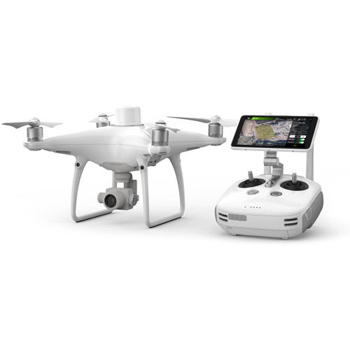
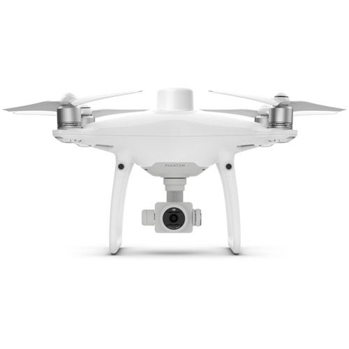
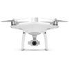
Phantom 4 RTK
Visionary Intelligence. Elevated Accuracy.
Upgrade your next mapping mission with the Phantom 4 RTK – DJI's most compact and accurate low altitude mapping solution.
Key Features:
- RTK Module
- 20MB 1" CMOS Sensor
- GS RTK APP
- TimeSync
- OcuSync
- D-RTK 2 GNSS Mobile Station
Next Generation Mapping
DJI has rethought its drone technology from the ground-up, revolutionizing its systems to achieve a new standard for drone accuracy – offering
Phantom 4 RTK customers centimeter-accurate data while requiring fewer ground control points.
-
1cm+1ppm
RTK Horizontal Positioning Accuracy
-
1.5cm+1ppm
RTK Vertical Positioning Accuracy
-
5cm* (*When flying at 100m height, 2.7cm GSD, sunny.)
Absolute Horizontal Accuracy of Photogrammetric Models
Centimeter Level Positioning System
A new RTK module is integrated directly into the Phantom 4 RTK, providing real-time, centimeter-level positioning data for improved absolute accuracy on image metadata. Sitting just beneath the RTK receiver is a redundant GNSS module, installed to maintain flight stability in signal-poor regions such as dense cities. Combining both modules, the Phantom 4 RTK is able to optimize flight safety while ensuring the most precise data is captured for complex surveying, mapping and inspection workflows.
Fit the Phantom 4 RTK to any workflow, with the ability to connect this positioning system to the D-RTK 2 Mobile Station, NTRIP (Network Transport of RTCM via Internet Protocol) using a 4G dongle or WiFi hotspot, or store the satellite observation data to be used for Post Processed Kinematics (PPK).
Gather Accurate Data with TimeSync
To take full advantage of the Phantom 4 RTK’s positioning modules, the new TimeSync system was created to continually align the flight controller, camera and RTK module. Additionally, TimeSync ensures each photo uses the most accurate metadata and fixes the positioning data to the center of the CMOS – optimizing the results from photogrammetric methods and letting the image achieve centimeter-level positioning data.
Precise Imaging System
Capture the best image data with a 1-inch, 20 megapixel CMOS sensor. The mechanical shutter makes mapping missions or regular data capture seamless as the Phantom 4 RTK can move while taking pictures without the risk of rolling shutter blur. Due to the high resolution, the Phantom 4 RTK can achieve a Ground Sample Distance (GSD) of 2.74 cm at 100 meters flight altitude. To ensure each Phantom 4 RTK offers unparalleled accuracy, every single camera lens goes through a rigorous calibration process where radial and tangential lens distortions are measured. The distortion parameters gathered are saved into each image’s metadata, letting post-processing software adjust uniquely for every user.
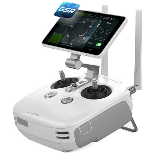
Purpose-Built Flight Planning Application
A new GS RTK app allows pilots to intelligently control their Phantom 4 RTK, with two planning modes – Photogrammetry and Waypoint Flight – alongside a more traditional flight mode. The planning modes let pilots select the drone’s flight path while adjusting overlap rate, altitude, speed, camera parameters and more, offering an automated mapping or inspection workflow.
The GS RTK app has been built with its users in mind and therefore has a range of features built for specific mapping or inspection workflows. The app has implemented direct loading of KML area files for in-office flight planning, a new shutter priority mode to keep exposure consistent across all photos and a strong wind alarm to warn pilots of adverse conditions.
Mobile SDK Supported
The Phantom 4 RTK is compatible with the DJI Mobile SDK, opening up its functions to automation
and customization through a mobile device.
OcuSync Transmission System
Enjoy stable and reliable HD image and video transmission at distances of up to 7 km, great for mapping larger sites.
*Unobstructed, free of interference, when FCC compliant. Maximum flight range specification is a proxy for radio link strength and resilience. Always fly your drone within visual line of sight unless otherwise permitted.
Support your Phantom 4 RTK missions with the D-RTK 2 Mobile Station
Providing real-time differential data to the drone and forming an accurate surveying solution. The Mobile Station’s rugged design and OcuSync 2.0 transmission system ensures you can gain centimeter-level accurate data with your Phantom 4 RTK in any condition.
D-RTK 2 High Precision GNSS Mobile Station
Optimized Accuracy. Ultimate Reliability.
D-RTK 2 Mobile Station is DJI’s upgraded high-precision GNSS receiver that supports all major global satellite navigation systems, providing real-time differential corrections that generate centimeter-level positioning data for improved relative accuracy.
Centimeter-Level Positioning
D-RTK 2 Mobile Station fully supports GPS, GLONASS, Beidou, and GALILEO signals. Easy and quick to set up, the D-RTK 2 Mobile Station provides real-time differential data for drones to achieve centimeter-level positioning accuracy. The built-in high-gain antenna offers better signal reception from more satellites even when obstructions are present.
Stay Connected for Any Mission
D-RTK 2 Mobile Station supports communication via 4G, OcuSync, WiFi, and LAN, ensuring uninterrupted, stable data transmission under any application scenario. Up to 5 remote controllers* can be connected to D-RTK 2 Mobile Station simultaneously. This makes coordinated operations involving multiple drones a possibility, significantly improving efficiency.
* MG-1P and Phantom 4 RTK standard remote controllers. This function is not supported on the D-RTK 2 Mobile Station For Matrice Series.
Durability You Can Trust
Featuring IP65 level ingress protection and a lightweight carbon fiber body, the D-RTK 2 Mobile Station is ultra-portable and up for any task, no matter how tough. The built-in IMUs monitor movements and calibrate the tilt sensors to alert the operator of any abnormalities during the mission, minimizing risks.
Start Mapping Today
With a built-in flight planning app (GS RTK) and aneasymethod to collect RTK data (RTK Network or D-RTK 2 Mobile Station), pilots have a full solution for any surveying, mapping or inspection workflow – right out of the box.
What's Included
Phantom 4 RTK Aircraft BodyRemote Controller
D-RTK 2 GNSS Mobile Station
4x Propellers (Pair)
2x Intelligent Flight Batteries
AC Power Adapter
AC Power Cable
Intelligent Battery Charging Hub
Intelligent Flight Battery Charging Hub
Gimbal Clamp
microSD Card (16GB)
Micro USB Cable
USB-C Cable
USB-C OTG Cable
Carrying Case
For Québec Residents – Disclosure Under the Consumer Protection Act
In compliance with Bill 29, Vistek does not guarantee the availability of replacement parts, repair services, or maintenance or repair information for products sold by Vistek.
Coverage provided through applicable manufacturer warranties, if any, remains in effect. Customers are encouraged to contact the manufacturer directly for information regarding the availability of replacement parts, repair services, or maintenance information.
Reviews
Product Specifications
PHANTOM 4 RTK |
|
|---|---|
Aircraft |
|
| Takeoff Weight | 1391 g |
| Diagonal Distance | 350 mm |
| Max Service Ceiling Above Sea Level | 19685 ft (6000 m) |
| Max Ascent Speed | 6 m/s (automatic flight); 5 m/s (manual control) |
| Max Descent Speed | 3 m/s |
| Max Speed | 31 mph (50 kph)(P-mode) 36 mph (58 kph)(A-mode) |
| Max Flight Time | Approx. 30 minutes |
| Operating Temperature Range | 32° to 104° F (0° to 40℃) |
| Operating Frequency | 2.400 GHz to 2.483 GHz (Europe, Japan, Korea) 5.725 GHz to 5.850 GHz (United States, China) |
| Transmission Power (EIRP) | 2.4 GHz CE (Europe) / MIC (Japan) / KCC (Korea) :< 20 dBm 5.8 GHz SRRC(China) / FCC(United States)/NCC(Taiwan,China):< 26 dBm |
| Hover Accuracy Range | RTK enabled and functioning properly: Vertical:±0.1 m;Horizontal:±0.1 m RTK disabled Vertical:±0.1 m(with vision positioning ); ±0.5 m(with GNSS positioning) Horizontal:±0.3 m(with vision positioning); ±1.5 m(with GNSS positioning) |
| Image Position Offset | The position of the camera center is relative to the phase center of the onboard D-RTK antenna under the aircraft body's axis:(36, 0, and 192 mm) already applied to the image coordinates in Exif data. The positive x, y, and z axes of the aircraft body point to the forward, rightward, and downward of the aircraft, respectively. |
Mapping Functions |
|
| Mapping Accuracy ** | Mapping accuracy meets the requirements of the ASPRS Accuracy Standards for Digital Orthophotos Class Ⅲ ** The actual accuracy depends on surrounding lighting and patterns, aircraft altitude, mapping software used, and other factors when shooting. |
| Ground Sample Distance(GSD) | (H/36.5) cm/pixel, H means the aircraft altitude relative to shooting scene (unit: m) |
| Data Acquisition Efficiency | Max operating area of approx. 1 km² for a single flight(at an altitude of 182 m, i.e., GSD is approx. 5 cm/pixel, meeting the requirements of the ASPRS Accuracy Standards for Digital Orthophotos Class Ⅲ |
Vision System |
|
| Velocity Range | ≤31 mph(50 kph) at 6.6 ft(2 m) above ground with adequate lighting |
| Altitude Range | 0-33 ft(0 - 10 m) |
| Operating Range | 0-33 ft(0 - 10 m) |
| Obstacle Sensing Range | 2-98 ft(0.7-30 m) |
| FOV | Forward/Rear: 60° (horizontal), ±27° (vertical) Downward: 70° (front and rear), 50° (left and right) |
| Measuring Frequency | Forward/Rear:10 Hz; Downward: 20 Hz |
| Operating Environment | Surfaces with clear patterns and adequate lighting(> 15 lux) |
Camera |
|
| Sensor | 1" CMOS; Effective pixels: 20 M |
| Lens | FOV 84°;8.8 mm / 24 mm(35 mm format equivalent:24 mm); f/2.8 - f/11, auto focus at 1 m - ∞ |
| ISO Range | Video:100-3200(Auto) 100-6400(Manual); Photo:100-3200(Auto) 100-12800(Manual) |
| Mechanical Shutter Speed | 8 - 1/2000 s |
| Electronic Shutter Speed | 8 - 1/8000 s |
| Max Image Size | 4864×3648(4:3); 5472×3648(3:2) |
| Video Recording Modes | H.264,4K:3840×2160 30p |
| Photo Format | JPEG |
| Video Format | MOV |
| Supported File Systems | FAT32(≤ 32 GB); exFAT(> 32 GB) |
| Supported SD Cards | MicroSD, Max Capacity: 128 GB. Class 10 or UHS-1 rating required Write speed≥15 MB/s |
| Operating Temperature Range | 32° to 104° F (0° to 40℃) |
Intelligent Flight Battery |
|
| Model | PH4-5870MAH-15.2V |
| Capacity | 5870 mAh |
| Voltage | 15.2 V |
| Battery Type | LiPo 4S |
| Energy | 89.2 Wh |
| Net Weight | 468 g |
| Charging Temperature Range | 14° to 104℉(-10° to 40℃) |
| Max charging Power | 160 W |
Intelligent Battery Charging |
|
| Model | WCH2 |
| Input Voltage | 17.3 - 26.2 V |
| Output Voltage and Current | 8.7 V,6 A;5 V,2 A |
| Operating Temperature | 41° to 104℉(5° to 40℃) |
GNSS |
|
| Single-Frequency, High-Sensitivity GNSS Module | GPS+BeiDou+Galileo(Asia); GPS+GLONASS+Galileo(other regions) |
| Multi-Frequency Multi-System High-Precision RTK GNSS | Frequency Used: GPS:L1/L2; GLONASS:L1/L2; BeiDou:B1/B2; Galileo:E1/E5a First-Fixed Time:< 50 s Positioning Accuracy: Vertical 1.5 cm + 1 ppm(RMS); Horizontal 1 cm + 1 ppm(RMS) 1 ppm means the error has a 1mm increase for every 1 km of movement from the aircraft. |
Gimbal |
|
| Stabilization | 3-axis (tilt, roll, yaw) |
| Pitch | -90° to +30° |
| Max Controllable Angular Speed | 90°/s |
| Angular Vibration Range | ±0.02° |
Infrared |
|
| Obstacle Sensing Range | 0.6-23 ft(0.2 - 7 m) |
| FOV | 70°(Horizontal) ±10°(Vertical) |
| Measuring Frequency | 10 Hz |
| Operating Environment | Surface with diffuse reflection material, and reflectivity> 8%(such as wall,trees, humans, etc.) |
Remote Controller |
|
| Operating Frequency | 2.400 GHz-2.483 GHz(Europe,Japan,Korea) 5.725 GHz-5.850 GHz(United States, China) |
| Transmission Power (EIRP) | 2.4 GHz CE / MIC / KCC:< 20 dBm 5.8 GHz SRRC / FCC:< 26 dBm |
| Max Transmission Distance | FCC:4.3 mi(7 km); SRRC / CE / MIC / KCC:3.1 mi(5 km) (Unobstrcted, free of interference) |
| Power Consumption | 16 W(typical value) |
| Display | 5.5 inch screen, 1920×1080, 1000 cd/m², Android System Memory 4G RAM+16G ROM |
| Operating Temperature Range | 32° to 104° F (0° to 40℃) |
Intelligent Flight Battery Charging Hub |
|
| Model | PHANTOM 4 CHARING HUB |
| Voltage | 17.5 V |
| Operating Temperature Range | 41° to 104℉(5° to 40℃) |
| Capacity | 4920 mAh |
| Voltage | 7.6 V |
| Battery Type | LiPo 2S |
| Energy | 37.39 Wh |
| Operating Temperature | -4° to 104℉(-20° to 40℃) |
AC Power Adapter |
|
| Model | PH4C160 |
| Voltage | 17.4 V |
| Rated Power | 160 W |
D-RTK 2 |
|
|---|---|
GNSS RECEVIER |
|
| GNSS Frequency | Simultaneously receive: GPS: L1 C/A, L2, L5 BEIDOU: B1, B2, B3 GLONASS: F1, F2 Galileo: E1, E5A, E5B |
| Positioning Accuracy | Single Point Horizontal:1.5 m(RMS) Vertical:3.0 m(RMS) RTK Horizontal:1 cm+ 1 ppm(RMS) Vertical:2 cm+ 1 ppm(RMS) 1 ppm: For every 1 km increase in distance, the accuracy will be 1 mm less. For example, the horizontal accuracy is 1.1 cm when the receiving end is 1 km away from the base station. |
| Positioning Update Rate | 1 Hz, 2 Hz, 5 Hz, 10 Hz and 20 Hz |
| Cold Start | <45 s |
| Hot Start | <10 s |
| Recapture Time | <1 s |
| Initialization Reliability | >99.9% |
| Differential Data Format | RTCM 2.X/3.X |
IMU |
|
| Features | Built-in high-precision 6-axis accelerometer D-RTK 2 movement monitoring Sloping measurements Electronic bubble level |
COMMUNICATION AND DATA STORAGE |
|
| Data Link | OcuSync, Wi-Fi, LAN, 4G |
| Operating Frequency | 2.400 GHz to 2.483 GHz (China, United States, Australia, Europe, Japan, Korea) 5.725 GHz to 5.850 GHz (China, United States, Australia) |
| EIRP | OcuSync 2.4 GHz SRRC (Mainland China) / CE (Europe) / MIC (Japan) / KCC (Korea): < 20 dBm FCC (United States, Australia) / NCC (Taiwan, China): < 26 dBm 5.8 GHz FCC (United States, Australia) / SRRC (Mainland China) / NCC (Taiwan, China): < 26 dBm Wi-Fi 2.4 GHz SRRC (Mainland China) / CE (Europe) / MIC (Japan) / KCC (Korea): < 20 dBm FCC (United States, Australia) / NCC (Taiwan, China): < 22 dBm 5.8 GHz FCC (United States, Australia) / SRRC (Mainland China) / NCC (Taiwan, China): < 22 dBm |
| Communication Distance | OcuSync: 2 km (unobstructed and free of interference, when the distance from the D-RTK 2 antenna to the bottom of the tripod is 1.8 m, when the difference in height between the remote controller and D-RTK 2 is less than 2 m, and when the remote controller is 1.2 m from ground level) |
| Memory Capacity | 16 GB |
ELECTRICAL CHARACTERISTICS |
|
| Power Consumption | 12 W |
| Power Supply | 16.5 to 58.8VDC |
| Battery | Type:Lithium-ion battery Capacity: 4920 mAh Energy: 37.3 WH |
| Run Time | WB37 battery:>2 h MG-12000P battery:>50 h |
OPERATING TEMPERATURE |
|
| Operating Temperature | 32° to 113° F (0° to 45° C) |
PHYSICAL SPECS |
|
| Dimensions(D-RTK 2 body with extension rod) | 68 mm×168 mm×1708 mm |
| IP Rating | IP65 |
Questions & Answers
DJI Phantom 4 RTK with D-RTK 2 Mobile Station
Looking for a personal touch? Not sure if you are choosing the right product? Our staff is here to help.
We want to make sure you get the right product for your needs.
Our staff will help you understand the options available so you can be confident in your purchase.
As the country’s leading Professional Imaging retailer, Vistek is in the perfect position to ensure you make the right choice.
Contact us today for a personal touch.